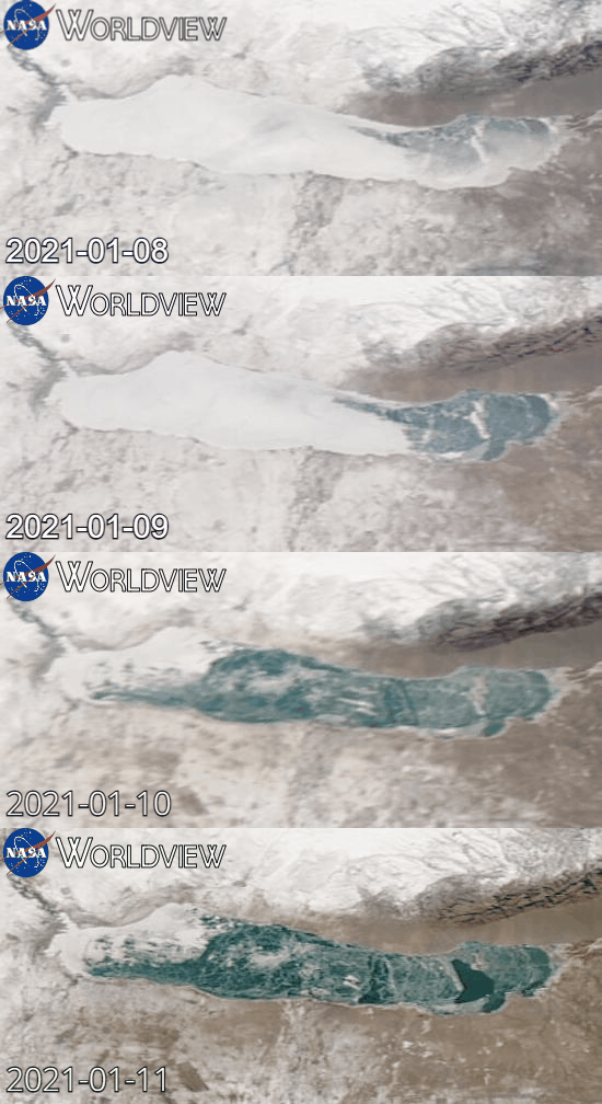
The event of ice drift and nearshore ice rafting and ridges formation process was observed on 10th of January 2021 in Kapchagay reservoir near Almaty, Kazakhstan.
General information
Kapchagay
reservoir located in Kazakhstan, Almaty region, 50km north from Almaty
city. The size of freshwater lake is about 85km long stretched from east
to west and 20km wide. The maximum depth is about 45m. Every winter it
is covered with freshwater ice. The overview of ice conditions on the
lake is presented on Sentinel-2 images below for 10th January (prior to
event) and 12th January (2 days after event) as well as on MODIS images
for period from 8th to 11th January.

Event on 10th January 2021
On 10th January 10-13 m/s ESE wind was forecasted in the area during the noon time with gusts up to 20 m/s. The observation point was located in the north-western shore of the lake (marked on images above).
The initial ice conditions along the shore were presented by level ice with inclusion of ridges with heights of 0.5m maximum located about 50m from the shoreline (Sentinel-2 image below). This area in known for shallow water of about 0.5-1m depth 50-100m away from shore. The event has started about 12:45 Local time (-6 GMT) when ice cover has started to drift towards the shore initially accompanied by dull cracks. The break of ice sheet and subsequent formation of ice ridges started 100m away from shore. That was due to thicker and more stabilised by existing ridges ice closer to shore. The intense ice rafting and ridge formation process was observed for 20-30 minutes.
Two Sentinel-2 images below show initial ice conditions prior to event on 10th January 2021 and resulting ice conditions after the event.
The event has resulted in buildup of continuous chain of grounded ridges along the whole shore with keel heights of 4-6m (observed visually) and width of 30-50m. The ice thickness was estimated to be in range of 20-35cm. The ERA5 reanalysis of wind data in the area of the lake has shown speeds in the range of 7.5-9.5 m/s. Unfortunately, there is no representative meteorological station data available in the area. The analysis of Sentinel-2 satellite images has shown the shift of ice cover by 800-850 m, which results in significant estimated drift speeds of 0.45-0.65 m/s during the event.


