27ᵗʰ International Conference on Port and Ocean Engineering under Arctic
Conditions was held in Glasgow this year. After a four-year break from publications, Iceman had a lot to share.
ICEMAN.KZ has attended
with their contribution to community with presentation of new results
and achievements of internal projects. It is our strong commitment to
experience exchanging and sharing information that has contributed to
our growth and development.
POAC23 was held in Glasgow this year. After a four-year break from publications, Iceman
Sharing the Caspian Sea News
Totally seven own and two cooperation articles were presented at this conference. The key focus is the Caspian Sea where our domain lays with research projects and experience of operations.
See our summary video on YouTube.
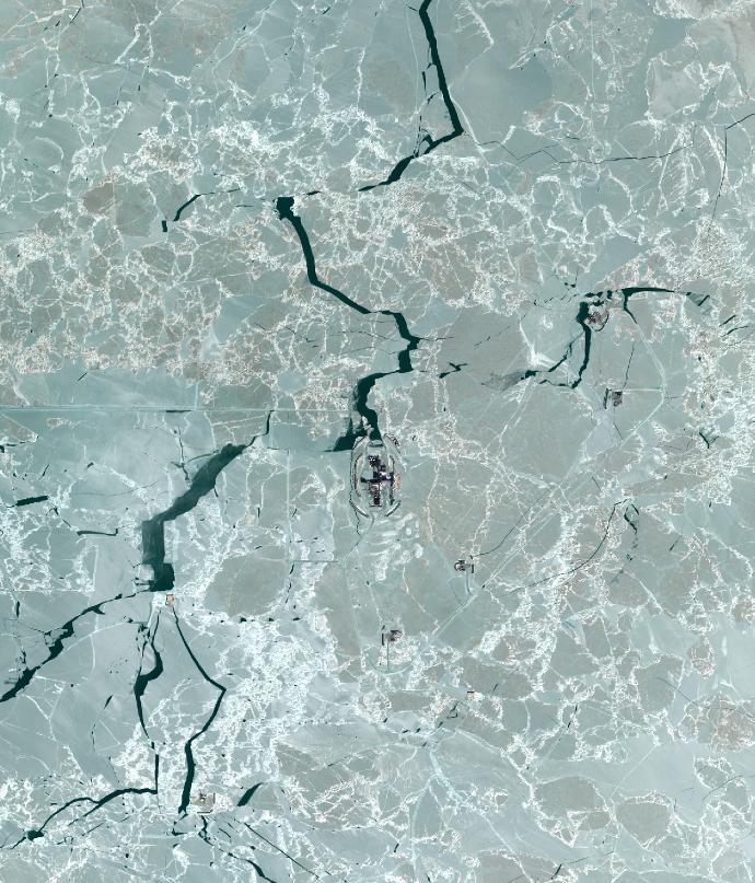
Caspian Sea Ice Cover Hindcast Database
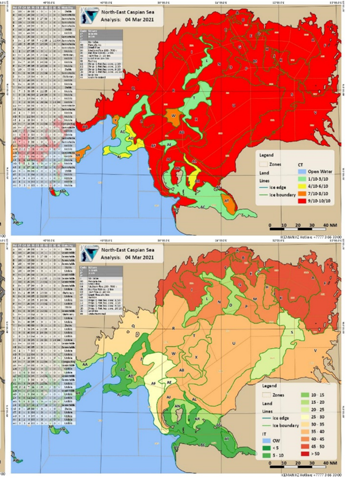
ICEMAN.KZ developed the database with daily observations covering the whole region with ice cover characterization. More than 8000 SAR (Synthetic Aperture Radar) and optical images were processed for ice charting purposes to derive ice charts and analysis to feed the database that now contains data from 2005 to the last ice season. Internal ice monitoring program and database structure were developed to suit operational and engineering applications for offshore activities.
Detailed Spatial Temporal Analysis of Caspian Sea Ice Thickness Distribution Based on Differentiated FDD
FDD and ice thickness records were compiled into a hindcast database for winter seasons starting from 2005 that is used to assess hazards for operations in ice, describe interaction mechanisms with offshore structures and to quantify impact. Seasonal variation of ice thickness and how ice masses are distributed over the sea are discussed in the paper.

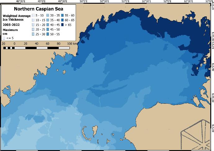
Caspian Ice Cover Mobility
Ice cover mobility is one of the most important ice cover parameters that allows estimating possibility of ice events and mode of ice interaction with offshore structures. It allows aggregating possible parameters when compiling scenarios for assessment of hazardous conditions affecting marine operations and emergency escape. This paper provides insights into temporal and spatial distribution of ice cover mobility over the Northern part of the Caspian Sea from 2005 to 2023 and its application for engineering purposes.
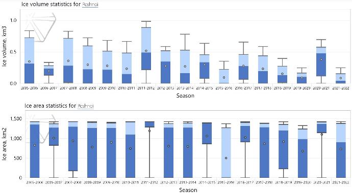
Caspian Seasonal Ice Volume Trends in the Recent History
The persistent reduction trend of ice volume and coverage over the whole Northern Caspian Sea through the record of the latest seasons in history illustrates the effect of climate change on the ice regime. Ice volume and coverage indexes are derived from consistent daily observations of ice cover. Direct hierarchy of relationship between these aggregated indexes and detailed records of ice conditions enables quantitative climate change impact assessment on operations occurring in the region.

Caspian Deformed Ice Cover Classification
Deformed ice is a general term for ice which has been squeezed together and in places forced upwards (and downwards). There are little to no physical observations available for the Caspian Sea region. Specifically, there is little knowledge available on spatial and temporal distribution of ice ridges. This article introduces results of unsupervised classification of SAR data using k-means algorithm that allows for automatic detection and segmentation of areas with low medium and high backscatter level that define degree of deformation.
Caspian Ice Cover Destabilization Wind Threshold
Continue reading
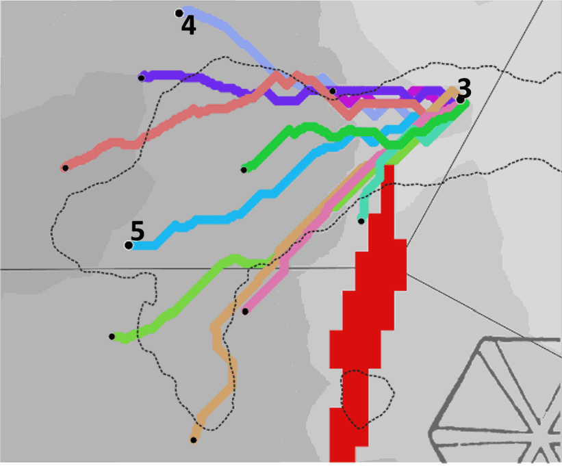
Marine Units Performance Simulation under Changing Environment in the Caspian Sea
Simulation was performed with Genetic Algorithm (GA) which is a heuristic algorithm for path search optimization as reanalysis using historical observations of ice conditions as input. Several transportation modes (conventional shallow water fleet, Air Cushion Vehicles (ACV) and Amphibious All-Terrain Vehicles (ATV)) were considered with their limiting conditions to understand the effects of changing environment and possibility to access ice covered shallow areas in the Northeastern Caspian. Downtime and travel time variation were used to illustrate joint action of reducing water level and depleting ice cover on logistical chain in the region.
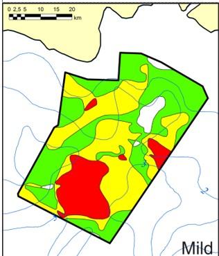
Ice gouging pattern on the Northern Caspian derived from SAR data
Ice gouging in the Caspian Sea has been studied for a long time for constructing and operating underwater pipelines from oil and gas fields to the land. Last time we defined the areas of stamukhi localization and presented a big picture of Caspian shelf zonation according to ice gouging intensity. Stamukhi are a terminal stage of deformed ice evolution, forming stable ice features affecting the bottom. New data on the degree of ice deformation from SAR image interpretations allowed us to improve the prediction of ice gouging intensity and ice scours formation all over the Northern Caspian.
POAC has once again proven its usefulness for ICEMAN.KZ as a proactive platform for exchange on technical and scientific development. Learning new trends in the world of sea ice engineering keeps us at the state-of-the-art level of technologies we apply in our daily operations